Your School. Your Paper. Since 1936.

The Suffolk Journal

Your School. Your Paper. Since 1936.

The Suffolk Journal

Your School. Your Paper. Since 1936.

The Suffolk Journal

Temperatures to plunge preceding Friday’s snow

Temperatures+to+plunge+preceding+Fridays+snow
Emily Devlin

It’s been a warm start to the week with Monday and Tuesday reaching highs in the 50s. The National Weather Service is forecasting highs for Wednesday into the upper 60s with light rain possible in the afternoon.

Don’t be caught off guard walking out the door Thursday when high temperatures drop back down to the 30s. Thursday will be mostly clear.

The cold front that moves in precedes a winter storm that will be hitting Boston by Friday morning. 

NBC10 is forecasting 8 to 12 inches of snow dumped from that storm as of Tuesday morning, however, it’s not yet clear how much of the precipitation will be mixed/rain.

Prepare for slippery conditions and possible MBTA service delays from Friday’s winter storm.

Cold temperatures along with mostly clear skies will stick around all weekend, likely until next week. 

Temperatures are expected to reach up to 70 degrees Fahrenheit on Wednesday, much higher than the average high temperature during this time of year, normally 40.5 degrees Fahrenheit according to NOAA. (Courtesy of the National Weather Service)

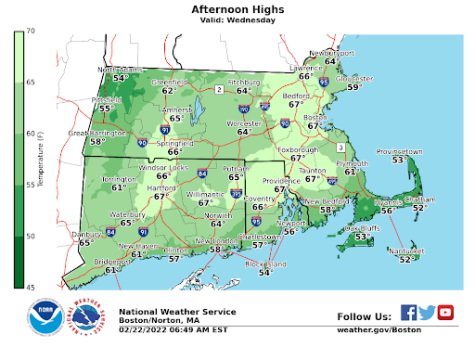
NOAA also forecasted a high of 67 degrees Fahrenheit on Wednesday, almost enough to break the record temperature for Feb. 24. The current record is 68 degrees Fahrenheit, set in 2017.

Boston.com, 7News, Boston 25 and others have referred to the drastic changes in temperature as “weather whiplash.” 

NBC10’s Meteorologist Pete Bouchard said the fluctuations in temperature is a product of climate change, writing “climate change is pulling the strings, but it takes an orchestra of coordination to keep this machine humming.”

The winter storm passing over Friday is expected to blanket Boston with 6” to 8” of snow. In a similar graphic, NOAA gave Boston a 65% chance to get 6” or more

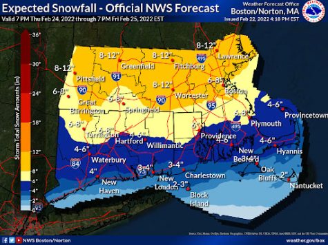
How much snow accumulation will come from Friday largely depends on where the rain-snow line ends up. Here’s what local stations are predicting: 7News says 6 to 9 inches, Boston 25 says 5 to 8 inches and CBS Boston says 4 to 8 inches.

Either way, precipitation will make Friday’s commute dangerous.

Sunday is looking to be the warmest day for the mostly sunny weekend, reaching a high near 38 degrees Fahrenheit. 

Weather information is retrieved from the national weather service. For a more detailed forecast, visit

weather.gov.


Leave a Comment
More to Discover
About the Contributors
Jacob Murphy
Jacob Murphy, Meteorologist/Staff Writer | he/him
Jacob is a senior studying broadcast journalism with a recently added environmental science minor. Growing up in Old Orchard Beach, Maine, Jacob got his start on the journalism track with his passion for weather forecasting and storm chasing. He ended up falling in love with the newsroom and hopes to one day become a weatherman. Outside of The Journal, Jacob spends a lot of his time acting as the President of Suffolk Volleyball Club; a club which he founded his freshman year. Follow Jacob on Twitter: @jafreese02
Emily Devlin
Emily Devlin, Managing Editor | she/her
Emily is a senior print/web journalism major and art history minor at Suffolk University. She loves traveling around Boston from museums to sports games. History is a significant interest of hers and she spends her free time wandering around the MFA, reading, writing, and listening to music. After college Emily hopes to work in a museum. Follow Emily on Twitter @emrodev Email her at [email protected]

Comments (0)

All The Suffolk Journal Picks Reader Picks Sort: Newest

Your email address will not be published. Required fields are marked *

Activate Search
Temperatures to plunge preceding Friday’s snow